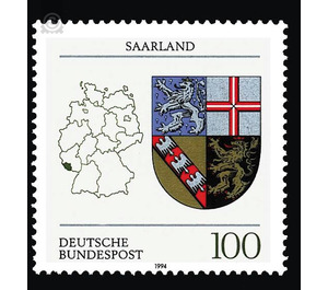
Coat of arms of the Land of the Federal Republic of Germany (3) - Germany / Federal Republic of Germany 1994 - 100 Pfennig
Theme: Art & Culture
| Country | Germany / Federal Republic of Germany |
| Issue Date | 1994 |
| Face Value | 100.00 |
| Color | multi-colored white |
| Perforation | K 13 3/4 |
| Printing Type | Multicolor offset printing |
| Stamp Type | Postage stamp |
| Item Type | Stamp |
| Chronological Issue Number | 1585 |
| Chronological Chapter | GER-BRD |
| SID | 666755 |
| In 49 Wishlists | |
The coat of arms of the Saarland is valid since the accession to the Federal Republic of Germany on 1 January 1957. It ties in with the four territories that had the largest territorial units here in the time of the Old Kingdom. In the most prominent place, in the heraldic right upper field, stands the coat of arms of the county of Saarbrücken, which occupied the center of today's country: It shows a gold-crowned, red-silvered lion in a blue field sown with silver crosses. The coat of arms was at the same time the coat of arms of the temporary sovereigns, the count of Saarbrücken-Commercy. This Lorraine gender was replaced in 1381 by the Counts of Nassau, who ruled here in different lines until the French Revolution, in close dynastic connection with the right bank of the Rhine areas of the Nassauwalramischen house. Heraldic top left is the red polished cross bar in the silver field of the Electorate of Trier, which possessed areas in the north of present-day Saarland. Below right follows the coat of arms of the Dukes of Lorraine: with three mutilated d. H. the claws and beak robbed, silver eagles occupied red oblique right beams in golden field. The Lorraine territory today occupied parts of Saarland, especially in the west. The coat of arms on the lower left is that of the Duchy of Palatinate-Zweibrücken, which had territories in the east: red-crowned and red-armored golden lion in black field. The old order was swept away by the French Revolution. The area of today's Saarland became part of the new French territory on the left bank of the Rhine. The Second Paris Peace (November 20, 1815) struck the bulk of the Saar area with Saarbrücken and Saarlouis Prussia (Rhine Province); the eastern part with St. Ingbert and Homburg came to the Bavarian Rheinpfalz. In the north of present-day Saarland shares received the Oldenburg Principality Birkenfeld and the Saxon-Coburg Principality of Lichtenberg (St. Wendel: since 1834 Prussian). The rapid rise of heavy industry in the center of today's Saarland (coal, iron, glass) since about the middle of the 19th century led to an increasingly clear weight of the region in many areas; Out of several marginal landscapes, a core landscape emerged. This dead weight was the prerequisite for the later political summary of the Saarland district in its own limits; It is also the basis of the autonomy of the state of Saarland. Under the influence of France, which wanted to secure the economic power of the Saarland, the Saar area after the First World War in the Versailles Treaty of 1920 was subordinated to a League of Nations Government (Government Commission). In the plebiscite of 1935 envisaged in the treaty, the population voted for Germany, even though the motherland was ruled by Hitler. The Saarland was not rebuilt into its old parts, but remained - in close connection with the Palatinate - under a Reich Commissioner as "Saarland" independently. At the end of the Second World War, the country - now especially in the north territorially increased - again under French influence. The state of quasi-state ownership since 1947 was only ended after the population had clearly rejected the so-called European statute of the Saarland negotiated between France and the Federal Republic on 23 October 1955 and France had consented to its incorporation into the Federal Republic. The political integration on 1 January 1957 was followed by the economic integration on "Day X", 6 July 1959. The Saarland has a surface area of 2,570.24 km2 and 1,084,007 inhabitants (as of December 31, 1992). (Text: Dr. Wolfgang Laufer, Landesarchiv Saarbrücken)


